The recent flooding caused by Hurricane Harvey got me to thinking about flooding where I live because, after all, we live very near the water’s edge along the Puget Sound. And, while we’re likely high enough that any minor flooding wouldn’t be a problem… what if something BIG happened? Where would we go?
Well, as planning would have it, I do have evacuation routes to get us well away from the area but I’ve come to realize that some of those involve driving (or maybe walking) very near likely flood-prone areas which obviously wouldn’t work out too well if the flooding occurred in relatively short order.
The other major problem I had with planning a quick evacuation due to flooding is that we’re surrounded by tall trees which makes it a bit more difficult to merely step out of my front door, take a gander, and decide which way is uphill. Where we used to live in Missouri it was no problem to look for miles on end in any direction… here that just isn’t possible.
So, I did what any good under-the-age-of-80 person would do: I turned to Google Maps. And, as it turns out, they have a handy little terrain feature which shows contour lines and elevation.
Just go to Google Maps, click the “Menu” button on the top left corner of the screen, and select “Terrain.” The map will transform into something resembling a topographical map with a bit shading denoting elevation and a few contour lines. Yes, there’s plenty still to be desired but it’s better than nothing.
What I don’t like about the Terrain feature of Google Maps is that if you either zoom too far in or too far out the contour lines and elevation markers disappear which makes it a tad difficult to use but still easy enough that I can look at where I live and figure out fairly quickly where I can go to get to higher ground in a few minutes drive… and I actually wouldn’t have thought about the particular spot I have in mind.
Anyway, I tried a few other interactive maps such as elevationmap.net which might actually be a better tool because it seems to include the same information as Google Maps but with the added benefit that you can click on a specific point on the map and click “Get informations” (yes, I spelled that correctly according to the tool) and you’ll see an altitude shown whereas Google Maps doesn’t seem to do so.
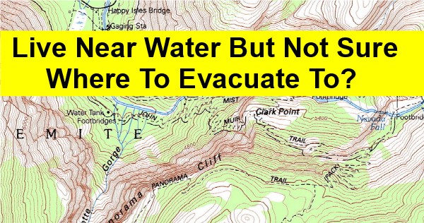
Last, if you’d like to see a more traditional interactive topographic map then try US Topo Map tool. Click on “Download Maps” on the left sidebar then you can search for your address, for example, and you’ll get a good map to make use of with contour lines, elevation, and more. The best part is that it’s all overlaid with streets so you can plan a route easily.
Hope this helps you figure out where best to evacuate to if flooding is a concern for you. Stay safe out there. 🙂
Leave a Reply